
3D LASER SCANNING
What is 3d Laser Scanning?
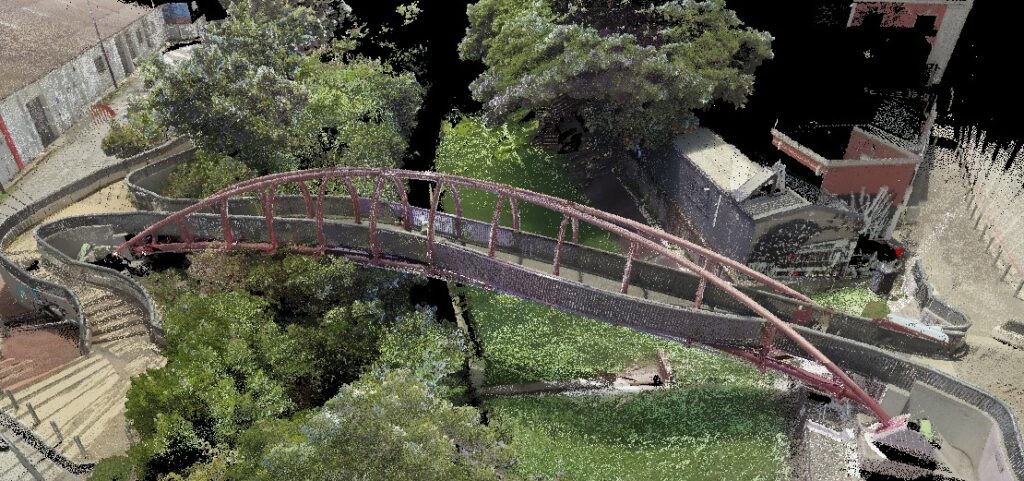
It is the technology whereby spatial data is captured using high-speed laser light. The shape and position of objects in the scanner’s field of view are recorded by millions of points. Each one of these points is positioned spatially by their measured XYZ coordinate. Such a group of points are known as a point cloud. Because each point in the point cloud is coordinated, various measurements, such as distance and height, can be taken down. Point clouds can also be georeferenced, enabling accurate measuring of globally correct coordinates. The true colour and dense composition of points in a point cloud provide the shape and form of the scanned environment. Additionally, all laser scanners have cameras that capture 360-degree imagery at every setup position. This imagery can be used to refer back to onsite conditions as captured at the time of the scan, or very often, it is used as virtual tours, especially in the hospitality and real estate industries.
Why Laser Scanning
Measuring spaces can be very time-consuming and requires skilled personnel experienced in producing high-quality surveys. Even the best surveyors miss that one portion of the information needed to complete a design. Very often, follow-up surveys and additional site visits must be made to get all the information required. There against, 3D laser scanning takes hundreds of thousands of highly accurate measurements every second. Capturing highly accurate data relatively quickly means significant time and productivity savings can be made. Furthermore, the point cloud data is supplemented with 360-degree panoramic imagery that can be referred to, to find that portion of the information that might have been missed using conventional survey methods.
Laser Scans For As-Built Information
As-Built – A drawing or model that directly reflects the current conditions of any structure, architectural, civil or mechanical
Before anything is built, it must be designed. Good design depends on sound and accurate information in architecture, engineering or industry. Remodelling and expansion require good as-built information. As-built drawings are notoriously inaccurate. Older structures may not have any plans available. Traditionally, existing buildings were surveyed or measured, and something was usually missed, which required returning to remeasure. Laser scanning takes 100 000’s point measurements every second and captures panoramic HDR imagery. The point cloud enables designers to measure and check dimensions from the offices, while the imagery allows them to look at the detail that might have been missed while on site. No more need for hundreds of photographs that still might have missed that specific detail required.
Reality Capture Scans
Laser scanners are true reality capture instruments. Point clouds are supplemented with HDR panoramic imagery. The combination of point clouds and imagery is widely applied in the following fields and included in the services we can deliver:
Documentation and Visualization:
Architectural Design: Reality capture is used in architecture to document existing structures and environments accurately. It aids in creating 3D models of buildings or landscapes, providing a detailed representation for design and visualization purposes.
Construction: In construction projects, reality capture helps monitor progress, compare as-built conditions against design plans, and identify potential issues early in the construction process.
Asset Management:
Facility Management: Reality capture assists in creating digital twins of facilities, helping facility managers visualize and manage assets more effectively. This can include tracking the location and condition of equipment and infrastructure.
Real Estate: In real estate, reality capture is utilized to create virtual tours and 3D models of properties, providing a more immersive experience for potential buyers or tenants.
Surveying and Mapping:
Land Surveying: Reality capture technologies, such as LiDAR and photogrammetry, are used in land surveying to accurately map terrains, measure distances, and create topographic maps.
GIS (Geographic Information System): Reality capture data can be integrated into GIS for better spatial analysis, urban planning, and resource management.
Cultural Heritage and Conservation:
Archaeology: Reality capture is employed to document and preserve archaeological sites, artefacts, and historical monuments. It helps in creating digital archives for research and conservation purposes.
Museum Exhibits: Museums use reality capture to create digital replicas of artefacts, enabling virtual exhibits and enhancing accessibility for a global audience.
Reality capture technologies include LiDAR, photogrammetry, 3D scanning, and drone-based surveys. The choice of technology depends on the specific requirements of the project or application.